I am a climate risk researcher passionate about sustainability and the environment. I am excited about nature-based solutions and community-based projects. In my free time, I love to be outside hiking, backpacking, rock climbing, or running!
2020-2025 Ph.D in Civil EngineeringPublications:Taken Courses:
Taught Courses:
Thesis:Regional models for coastal climate risk assessment: subsurface, multi-hazard, and risk reduction perspectives Advisor:Jack W. Baker | ||
2020-2022 M.S. in Structural EngineeringTaken Courses:
| ||
2016-2020 B.C.E in Civil EngineeringTaken Courses:
Extracurricular Activities:
Honors Thesis:Coastal versus Inland Hurricane Evacuation Behavior Analysis Advisor:Rachel Davidson |

I organized and validated Matlab functions for numerous ground motion models (GMMs), published in a report and GitHub repository. The report compares various functions and correlation models, documenting their use. Report available at https://purl.stanford.edu/qy113my5899.
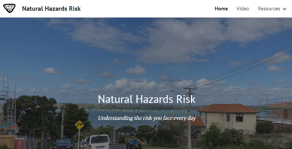
Made an interactive website with videos on natural hazard risk to housing as well as preparedness and risk resources. The site is no longer active.
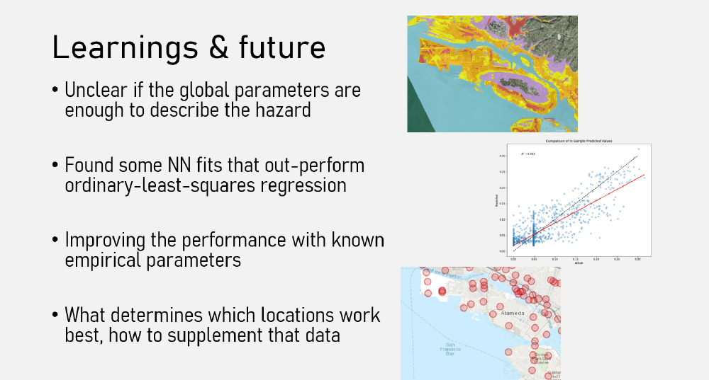
Applied machine learning to liquefaction hazard using neural networks. Achieved improved performance from Ordinary Least Squares regression.
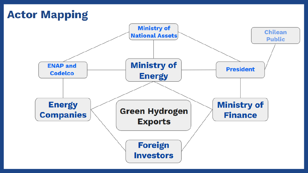
Analyzed the state of Chilean green hydrogen from economic, environmental, governance, and sustainability perspectives. Worked as a group to understand the challenges and opportunities, map the actors involved, chart the feedback loops, and understand tipping points and pathways to success.
After completing my thru hike of the PCT, I am writing a blog with information to others with dietary restrictions to help them plan and successfully thru hike the trail!
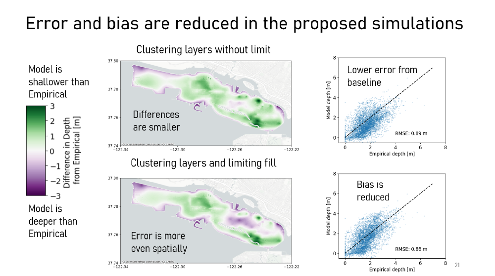
I modeled hydraulic conductivity layers on a regional scale to input to groundwater simulations and improve agreement between measured and modeled groundwater depths. Details are available in Chapter 5 of my dissertation, https://purl.stanford.edu/vh476mz1269.
Climate change is expected to increase the frequency and severity of many natural hazards. In particular, coastal communities are often exposed to multiple hazards, exacerbated by climate change. We present a methodology to quantify the increase in multi-hazard risk due to climate change. The methodology includes a probabilistic description of independent hazard pathways, defined as sets of individual and cascading hazards that are statistically independent, run for multiple levels of climate change impact. We also quantify the risk reduction from adaptation actions. The approach integrates probabilistic hazard analysis and loss assessment. With this approach, we identify the hazards contributing most to risk under multiple amounts of climate change. This methodology is applied to a case study of residential housing in Alameda, California, USA, considering how sea level rise impacts multiple hazards: earthquakes, coastal flooding, and tsunamis. For the case study location, we identify that the highest annualized risk shifts from earthquakes to coastal flooding as sea levels rise. We assess how different adaptation actions would reduce the risk today and under sea level rise, highlighting the need to consider frequent and infrequent losses.
The impact of liquefaction on a regional scale is not well understood or modeled with traditional approaches. This paper presents a method to quantitatively assess liquefaction hazard and risk on a regional scale, accounting for uncertainties in soil properties, groundwater conditions, ground-shaking parameters, and empirical liquefaction potential index equations. The regional analysis is applied to a case study to calculate regional occurrence rates for the extent and severity of liquefaction and to quantify losses resulting from ground shaking and liquefaction damage to residential buildings. We present a regional-scale metric to quantify the extent and severity of liquefaction. A sensitivity analysis on epistemic uncertainty indicates that the two most important factors on output liquefaction maps are the empirical liquefaction equation, emphasizing the necessity of incorporating multiple equations in future regional studies, and the ground motion model, highlighting the same necessity for the peak ground acceleration input. Furthermore, the disaggregation of seismic sources reveals that triggering earthquakes for various extents of liquefaction originate from multiple sources, though primarily nearby faults and large magnitude ruptures. This finding indicates the value of adopting regional probabilistic analysis in future studies to capture the diverse sources and spatial distribution of liquefaction.
Post-disaster housing recovery models increase our understanding of recovery dynamics, vulnerable populations, and how people are affected by the direct losses that disasters create. Past recovery models have focused on single-family owner-occupied housing, while empirical evidence shows that rental units and multi-family housing are disadvantaged in post-disaster recovery. To fill this gap, this article presents an agent-based housing recovery model that includes the four common type-tenure combinations of single- and multi-family owner- and renter-occupied housing. The proposed model accounts for the different recovery processes, emphasizing funding sources available to each type–tenure. The outputs of our model include the timing of financing and recovery at building resolution across a community. We demonstrate the model with a case study of Alameda, California, recovering from a simulated M7.0 earthquake on the Hayward fault. The processes in the model replicate higher non-recovery of multi-family housing than single-family housing, as observed in past disasters, and a heavy reliance of single-family renter-occupied units on Small Business Administration funding, which is expected due to low earthquake insurance penetration. The simulation results indicate that multi-family housing would have the highest portion of unmet need remaining; however, some buildings with unmet needs are anticipated to be able to obtain a large portion of their funding. The remaining portion may be filled using personal financing or may be overcome with downsizing or downgrades. Multi-family housing would also benefit the most from Community Development Block Grants for Disaster Recovery (CDBG-DR). This benefit is a result of modeling the financing sources, that CDBG-DR is available, and that many multi-family buildings do not qualify for other sources. Communities’ allocation of public funding is important for housing recovery. Our model can help inform and compare potential financing policies to allocate public funds.
Although hurricanes can cause severe hazard effects well inland, little is known about the evacuation behaviour of inland populations compared to coastal populations. Using survey data collected in the United States after Hurricanes Florence (2018), Michael (2018), Barry (2019), and Dorian (2019), we investigate differences between coastal and inland populations in evacuation decisions and timing, and their causes. The data indicate that coastal populations evacuated at a higher rate than their inland counterparts (those not in coastal counties) in every hurricane studied. Chi-square tests identified differences in characteristics of coastal and inland populations, and a multiple logistic regression identified variables associated with evacuation. Together they suggest multiple factors that help explain the difference in evacuation rates. The most significant findings were related to geographic differences in the issuance of evacuation orders and reported receiving of orders (whether or not orders were actually issued). Most interestingly, the analysis indicates that variance between inland and coastal evacuation is not fully explained by the factors suggested in existing literature. We suggest here that differences between inland and coastal evacuation may also result from risk perception, in particular, a view that hurricanes are a coastal phenomenon and therefore do not apply to inland populations.
Generation of three-dimensional models of damaged low-rise large-volume steel structures using Structure-from-Motion and light detecting and ranging technology. This project compares the different ways to create a point cloud and analyzes the accuracy of each method. The results from this project can be used to optimize future data collection and processing.


